Topical Research Areas
Atmospheric Boundary Layer
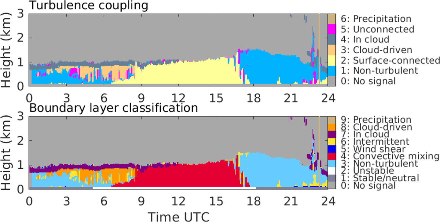
The figure shows a 24h JOYCE time series of the vertically resolved turbulence structure of the ABL (top) and a corresponding ABL classification (bottom); both time series have been derived from Doppler lidar observations (figure by Tobias Marke).
The lowest part of the atmosphere, which is strongly affected by the exchange of energy, water and momentum with the Earth surface, is the atmospheric boundary layer (ABL). Living in the ABL, humans are highly influenced by ABL processes which determine for example how quickly pollutants are removed, if turbulence is expected to influence air traffic or how much renewable energy is available. Resolving ABL processes is a key challenge for atmospheric models as they occur on rather small scales and are frequently connected with turbulence and a heterogeneous land surface. The research group
- performs ground based remote sensing using Doppler lidar, laser ceilometer and microwave radiometer to monitor ABL parameters (e.g. at JOYCE).
- develops retrieval techniques to unravel the vertical structure of the ABL (see figure)
- investigates how well the ABL is represented in models and how boundary layer observations can improve weather forecasts and reanalysis (HErZ).
- explores how patterns of the land surface influence ABL characteristics (TR32).
Cloud Processes
Starting from tiny aerosol particles, cloud microphysical processes lead to the formation, growth and decay of cloud droplets, rain drops and ice particles of different size and shape. These processes are organized within clouds which themselves are embedded in larger scale cloud fields. Clouds have a strong influence on where, when and how energy and water is distributed throughout the atmosphere and therefore their role in the climate system is of high importance, however to date not yet well understood. Similarly, model improvements are needed to answer the question when a cloud starts to precipitate and how efficiently water vapor can be converted into rain. The research group
- designs innovative active and passive microwave instruments for cloud remote sensing in cooperation with industry (e.g. Rose et al., 2005, Mech et al., 2014, Küchler et al., 2017).
- develops and applies multi-instrument retrieval techniques to identify cloud characteristics and processes (e.g. drizzle, fog, icing) in different climate zones (mid-latitude, Arctic, Caribbean, Atacama Desert).
- uses long-term observations and retrievals to improve cloud representation in models jointly with modelling groups (HD(CP)2).
Arctic Amplification
The Arctic is warming at a pace roughly twice as fast as the global average (this is what is termed Arctic Amplification) but the exact reasons are still unclear. The remote and hostile conditions make surface-based observations in the Arctic extremely sparse and at the same time satellites measurements suffer from lack of daylight and complex surface conditions. Therefore, it is no surprise that different reanalyses (representing the optimal weather reconstruction of the past) and - all the more climate modeling of the future - show a large spread among each other. Within the Transregional Collaborative Research Center on Arctic Amplification ((AC)3) the research group
- performs long-term cloud observations together with AWI at Ny Ålesund (Svalbard) and participates in international airborne campaigns.
- investigates mixed phase clouds, using airborne and ground based remote sensing, their impact on atmospheric radiation and thus their role in Arctic Amplification.
- analyses changes in water vapor and snowfall based on long-term microwave satellite observations as well as on reanalyses to infer the interaction of large-scale weather patterns with Arctic Amplification.
See the (AC)3 newsletter for more up-to-date information.
Energy Meteorology
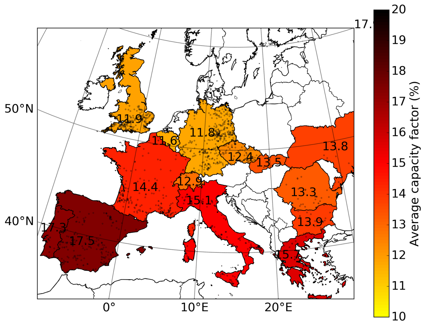
The figure shows country-wide averages of PV capacity factors (year 2015, aggregated from single solar power plant simulations) using the highly resolved European reanalysis COSMO-REA6. The information of installed PV capacity (> 3MW) and its spatial distribution (dotted) is provided by Wiki-Solar (figure by Christopher Frank).
The transition to renewable energy production is challenging because the availability of solar and wind power is highly variable in time and space. Thus, these power sources are very difficult to predict on the short time frames needed by the major energy suppliers. Also, the question how the spatial and temporal distribution of these energy sources might change in a warming climate needs to be answered. Furthermore, in terms of planning the power grid of the future, it is important to know when and where wind and solar energy production can compensate each other to satisfy the user demand. The research group
- combines remote sensing observations to characterize solar and wind power availability (ET-CC).
- uses novel reanalysis (e.g. COSMO-RE6 and COSMO-REA2) to derive climatologies of solar and wind power availability with high spatial and temporal resolution over Europe (HErZ).
- couples observations and reanalysis with models of energy production to derive for potential yields in photovoltaic (PV) and solar thermal power generation (Cooperation Hochschule Bonn-Rhein-Sieg).
Observational Networks of the Future
The demands on Numerical Weather Prediction (NWP) models are constantly growing. These include timely and more accurate forecasts of local severe weather (i.e. storm, precipitation, flooding, temperature extremes, low visibility etc..) but also cloudiness and winds for renewable energy applications. The advent of finer scale models (with horizontal grids sizes smaller than 1 km) also require more detailed observations, especially in the Atmospheric Boundary Layer (ABL). The research group, in close collaboration with the national and international weather services, space agencies and research partner institutes
- is developing observation standards for the cloudy ABL on a European basis (ACTRIS).
- is involved in the planning of future space-based satellite missions, e.g. MetOp Second Generation microwave instruments and EarthCare.
- quantifies the added value of combining satellite observations with novel ground-based remote sensing (ARON) and evaluates the potential of these instruments to improve the quality of weather forecasts.